
Maurepas Swamp: Inside Louisiana’s Largest Wildlife Management Area
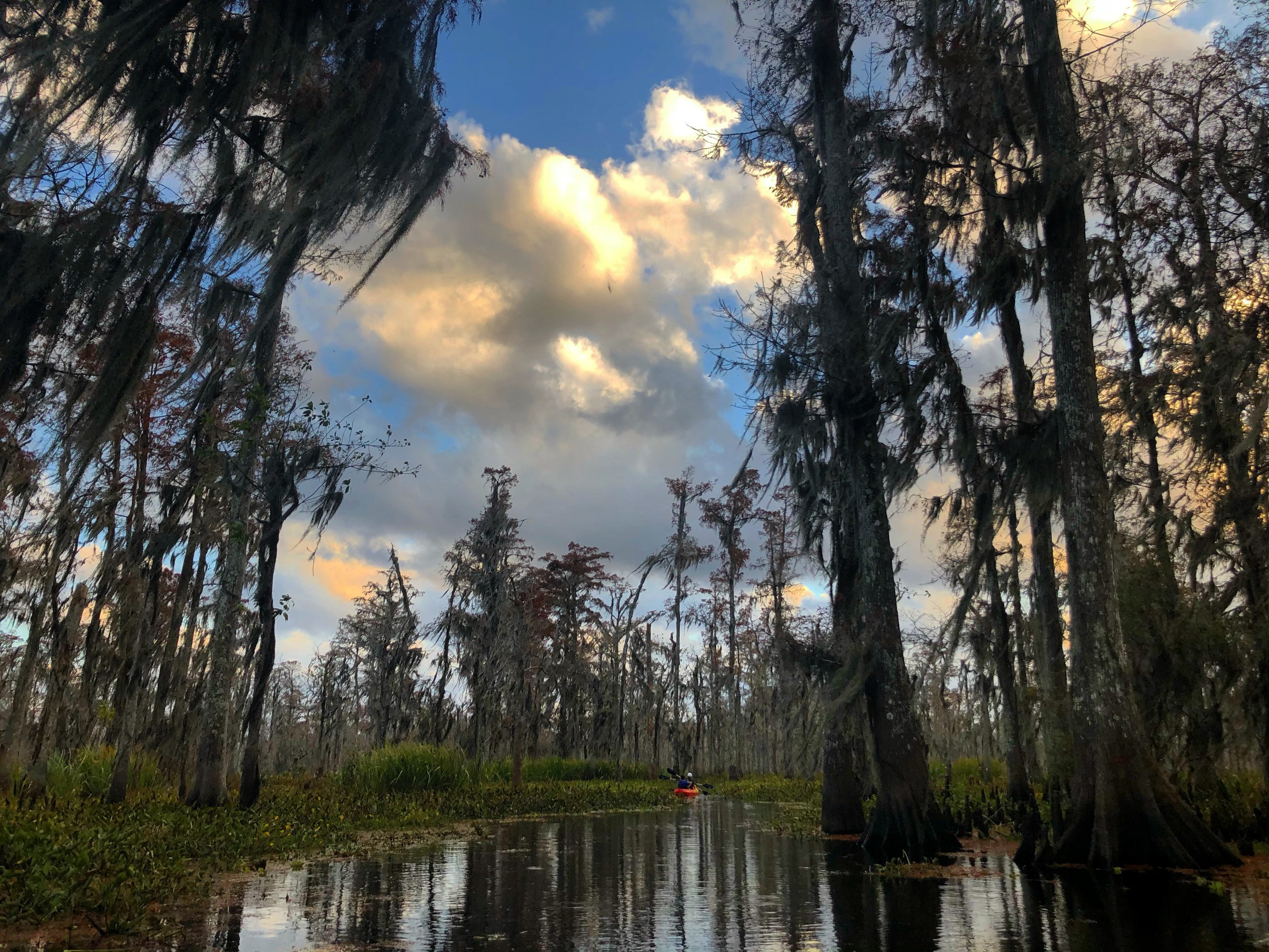
Ask a hundred visitors in New Orleans to name a swamp and most of them will say Honey Island, a few will say Manchac, and almost none will say Maurepas. Which is wild, because the Maurepas Swamp is the biggest protected wild place of the three. It’s the largest wildlife management area in the whole state. Over a hundred thousand acres of cypress and tupelo sitting maybe 25 miles west of the city, and it hides in plain sight.
We paddle the Manchac and Maurepas basin for a living, so this one’s personal. Maurepas is the quiet giant right next door to the swamp everybody knows. Here’s what it is, what lives in it, why it’s in trouble, and how to see it the right way.
The biggest swamp you’ve never heard of
The full name is the Maurepas Swamp Wildlife Management Area, and the number that matters is 112,615 acres. That makes it the largest WMA in Louisiana. Not one of the largest. The largest.
It’s managed by the Louisiana Department of Wildlife and Fisheries, which means it’s public wild land, not a park with a boardwalk and a gift shop. Hunting seasons, research, real ecosystem. The kind of place that has an eagle nest in it and nobody selling you a t-shirt at the trailhead.
And it’s basically anonymous to tourists. People drive right past it on I-55 heading north, same as they do the Manchac. The difference is Manchac at least gets ghost tours and a famous bridge. Maurepas just sits there being enormous.
Where the Maurepas Swamp actually is
Picture the two lakes north of New Orleans. Lake Pontchartrain is the big one on the city side. Lake Maurepas is the smaller one to the west. Pass Manchac connects the two lakes, the channel that runs through the heart of the swamp country.
The Maurepas Swamp sits on the south shore of Lake Maurepas, in the low, wet basin between the two lakes. Roughly 25 miles west of New Orleans. It’s the same basin, the same watershed, and the same tannin-dark water as the Manchac Swamp next door. Manchac and Maurepas aren’t two separate worlds. They’re one big connected swamp system, and the pass stitches them together.
So when you’re paddling the Manchac side, you’re paddling the eastern doorstep of Maurepas. The cypress don’t know where the WMA boundary line is drawn.
Cypress, tupelo, and the water in between
This is a bald cypress and tupelo swamp, the classic southern Louisiana kind. If you’ve seen a photo of Louisiana that made you want to visit, it was probably one of these: gray trunks going straight up out of black water, buttressed bases flaring out at the waterline, Spanish moss hanging dead-still on a windless morning.
Bald cypress is the tree everyone pictures. Water tupelo is its swamp partner, the one with the swollen base that looks like it’s standing on a stool. Together they make a flooded forest, a place where the line between land and water quits meaning much. Some of it is open water threaded with duckweed. Some of it is so thick with trunks you steer around them.
The water itself is the give-away that you’re in a healthy freshwater swamp. Dark, still, tea-colored from the tannins leaching out of leaves and bark. When it’s fresh and clean, the swamp works. That last part matters more than it sounds, and it’s where this story gets serious.
What lives out there
For a place most people never enter, Maurepas is loaded. It sits on the Mississippi Flyway, the continental migration corridor, so the bird traffic alone earns the trip.
On a good day in the basin, the cast includes:
- American alligators, the headliner, low in the water or stretched out on a log in the sun
- Wading birds by the armful: great blue herons, snowy and great egrets, and white ibis picking through the shallows
- Bald eagles and ospreys, both of which nest in this kind of swamp and hunt the open water
- Turtles stacked on any log that catches the sun, and snakes you’ll mostly see as a ripple heading the other way
- Nutria, the big invasive rodents that don’t belong here and chew the marsh apart anyway
- Migratory birds pouring through on the flyway in spring and fall, which is when the bird list gets long
We don’t promise you any single animal, and we won’t bait one to force a photo. That’s the trade with a real swamp. You see what it decides to show you. Some mornings that’s a gator a rod-length off the bow that has no idea you’re there, because a kayak makes no engine noise to warn it. If gators are the whole reason you’re coming, we mapped out where you can actually see gators around here.
The nutria are the one animal I’ll editorialize on. They’re South American, brought in for fur decades back, gone feral, and they eat marsh grass down to the root in patches that speed up the land loss the coast can least afford. Cute from a distance. A problem up close. And they’re a small preview of the bigger trouble.
The slow emergency: why this swamp is in trouble
Here’s the part I’d want you to know even if you never book a thing. The Maurepas Swamp is dying slowly, and it’s not from one villain. It’s three, stacked.
Saltwater intrusion. Salt water from the Gulf keeps pushing up into a swamp that’s built to be fresh. Cypress and tupelo can take a little brackish. They can’t take a steady dose. Salt in the roots is a slow poison for a freshwater forest.
Land subsidence. The whole basin is sinking. Southeast Louisiana is soft, settling ground to begin with, and the swamp is quietly dropping lower relative to the water around it.
Loss of Mississippi River sediment. This is the root cause under the other two. For thousands of years the Mississippi flooded and fed this basin, dropping fresh water and a fresh layer of silt that built land and kept the salt out. Then we walled the river off with levees to stop it flooding towns. Good for the towns. Terrible for the swamp. Cut off from the river’s fresh water and sediment, the basin has no way to rebuild itself or push the salt back. So it starves and sinks and takes on salt all at once.
You can read the same forces in the ghost cypress over in Manchac. Same basin, same problem. Maurepas is just bigger, so there’s more of it to lose.
What’s being done about it
It isn’t hopeless, and this is worth telling. There’s a major state restoration effort aimed right at Maurepas, the Maurepas Swamp diversion project. The idea is straightforward even if the engineering isn’t: reconnect the Mississippi River to the swamp so its fresh water and sediment can flow back into the basin the way they used to before the levees.
Reintroduce the fresh water and you push the salt back. Reintroduce the sediment and you start rebuilding the ground that’s been sinking. It’s an attempt to switch the river back on for this one starving stretch of swamp, in a controlled way, and slow the decline.
I’m not going to quote you a budget or a ribbon-cutting date, because those move around and I’d rather you trust what I tell you. The point is that Louisiana looked at its largest wildlife area heading downhill and decided it was worth trying to save. That tells you something about how much this place is worth. It’s a working effort to keep the biggest swamp in the state from turning into open salt water.
Why Maurepas gets skipped, and why that’s a shame
So why does nobody talk about it? A few honest reasons.
It’s harder to get into than the tourist swamps. There’s no famous ghost legend attached to it the way Julia Brown haunts the Manchac story. There’s no marquee boardwalk with a parking lot funneling people in. And it’s genuinely big and wild, which is exactly the thing that makes it worth seeing and also the thing that keeps the tour-bus crowd away.
That’s the whole appeal, honestly. Maurepas is the swamp that hasn’t been turned into a product yet. When you’re on the water in this basin you’re not in line behind six airboats. You’re in a hundred thousand acres of cypress that most people driving to New Orleans will never know they passed.
I’d rather you see this one than the postcard version. It’s the real thing.
How to actually experience it
Here’s where I stop being a brochure and tell you the truth about seeing a swamp this size. You can blow through it on an airboat, fast and loud, and watch somebody chuck marshmallows to make a gator perform. Or you can sit in a kayak, low on the water, no motor, and let the swamp forget you’re in it.
Only one of those actually shows you the place. Low and slow is how you hear it, a heron that won’t flush because you didn’t announce yourself with 300 horsepower, water so still it mirrors the trunks, the drip off your paddle the loudest thing around. Silent kayaks, small groups, a naturalist guide who knows the basin. That’s the whole reason this company exists.
We run our trips out of the Manchac end of this same basin, which is the doorstep of the Maurepas country. Our Manchac Swamp kayak tour is a two-hour guided paddle, small group, $65 a person, pickup at 740 N Rampart Street in New Orleans, no motors and no baiting. If you’re weighing when to come, here are the best months to paddle the Louisiana swamp. Book a morning trip if you want the fog and the quiet. That’s when a swamp this big tells you what it is.
See the swamp the right way.
Frequently Asked Questions
How big is the Maurepas Swamp?
The Maurepas Swamp Wildlife Management Area covers about 112,615 acres, which makes it the largest wildlife management area in Louisiana. It sits on the south shore of Lake Maurepas and is managed by the Louisiana Department of Wildlife and Fisheries. That’s a genuinely huge stretch of bald cypress and tupelo swamp, most of it wild and rarely visited.
Where is the Maurepas Swamp?
The Maurepas Swamp is on the south shore of Lake Maurepas, roughly 25 miles west of New Orleans. It sits in the low basin between Lake Maurepas and Lake Pontchartrain, the same swamp system as the neighboring Manchac area. Pass Manchac is the channel that connects the two lakes and ties the whole basin together, so Maurepas and Manchac are really one connected swamp.
Can you kayak the Maurepas Swamp?
Yes, and a kayak is the right way to see it. A silent, small-group paddle lets you slip through cypress and black water without an engine scaring off the wildlife. We run guided trips out of the Manchac end of this same basin, a two-hour paddle with a naturalist guide, no motors and no baiting. Low and slow is how you actually experience a swamp this size.
Why is the Maurepas Swamp under threat?
Three forces stacked together: saltwater intrusion from the Gulf, land subsidence as the basin sinks, and the loss of Mississippi River sediment after levees cut the river off from the swamp. Without fresh water and silt from the river, the swamp can’t push back the salt or rebuild sinking ground. A state restoration effort, the Maurepas Swamp diversion project, aims to reconnect the river and slow the decline.
Keep reading: the other famous bayous of Louisiana.